


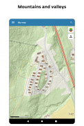
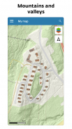
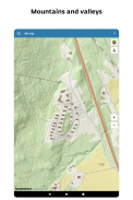


My map
Description of My map
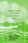
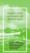
Lantm materiet, সুইডিশ ম্যাপিং, ক্যাডাস্ট্রাল এবং জমি রেজিস্ট্রেশন কর্তৃপক্ষ সুইডেনদের সবচেয়ে বিশদ এবং আপ টু ডেট মানচিত্র সরবরাহ করে। মানচিত্র যা প্রতিদিন আপডেট হয় এবং সিনপটিক সম্পত্তির সীমানা, বর্তমান পাশাপাশি historicতিহাসিক বায়বীয় ফটো এবং আরও অনেক কিছু দেখায় ...
বৈশিষ্ট্য:
- সুইডেনের একটি টপোগ্রাফিক মানচিত্র যা আমাদের সর্বাধিক আপডেট হওয়া অনলাইন সংস্করণ ধারণ করে
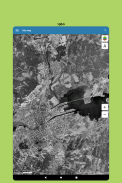
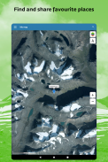
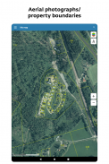
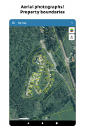
- জ্যামিতিকভাবে সংশোধিত এরিয়াল ফটো (অরথোফোটোস) সমন্বিত একটি মানচিত্র
- একটি হাইব্রিড মানচিত্র অনলাইন ব্যবহারের জন্য আমাদের টপোগ্রাফিক মানচিত্রের সাথে ভূখণ্ডের সিমুলেটেড আলোকসজ্জা সহ মনোনীত উচ্চতাগুলির একটি স্তরের সমন্বয়ে গঠিত
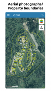
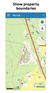
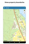
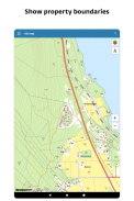
- সম্পত্তির সীমার একটি সংক্ষিপ্ত উপস্থাপনা (দয়া করে নোট করুন যে আপনি মানচিত্রে কয়েকটি স্তরের জুম না করা পর্যন্ত সীমানা দৃশ্যমান হবে না)
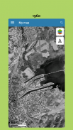
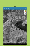
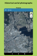
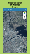
- প্রায় 1960 বা 1975 সালের Histতিহাসিক বিমানের ছবি photos
- আপনার ডিভাইসের জিপিএস রিসিভার অনুযায়ী মানচিত্রে আপনার অবস্থান চিহ্নিত করুন
- ঠিকানা, সম্পত্তি পদবী, স্থানের নাম বা স্থানাঙ্কের দ্বারা কোনও অবস্থান অনুসন্ধান করুন
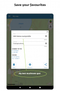
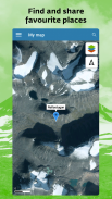
- মানচিত্রে আপনার পছন্দের জায়গাগুলি চিহ্নিত করুন এবং নাম দিন
- অ্যাপ্লিকেশন জুড়ে বা https://minkarta.lantmateriet.se এর সাথে চিহ্নিত জায়গাগুলি এবং লিঙ্কগুলি বন্ধুদের সাথে ভাগ করুন
- চিহ্নিত দূরত্ব এবং উচ্চতা বক্ররেখা পরিমাপ করুন
- অফলাইন মোডে ব্যবহারের জন্য অঞ্চলগুলি সংরক্ষণ করুন
অনলাইন ব্যবহারের জন্য ল্যান্টমিটারিয়েটস টপোগ্রাফিক মানচিত্র: এই মানচিত্রটি টোগোগ্রাফিক উপস্থাপন করে
শীর্ষস্থানীয় শব্দ, বিভিন্ন ধরণের সম্পদ, রাস্তা এবং রেলপথ ট্র্যাক, ঠিকানা, পর্বত সম্পর্কিত তথ্য, উচ্চতা বক্ররেখ ইত্যাদির মতো তথ্য
Lantmäteriets অর্থোপোটোস: জ্যামিতিকভাবে এরিয়াল ফটো রঙে সংশোধন করা হয়েছে। অ্যাপ্লিকেশন প্রতিটি সাইটের জন্য উপলব্ধ সর্বোচ্চ রেজোলিউশনের সর্বাধিক সাম্প্রতিক ছবি প্রদর্শন করে।
My map - Version 2.0.1
(14-02-2025)My map - APK Information
APK Version: 2.0.1Package: se.lantmateriet.minkartaLatest Version of My map
Other versions


 4.34
4.34


Apps in the same category


